Snapper Version (2.9)
April 25, 2025
Snapper 2.9 is the latest release of GeoMapFish, and the new features concern only the back-end.
New functionalities
- Upgrade MapServer to version 8
- Switch the Openlayers renderer to use WebGL for the WMTS
- Authentication enhancements
- For the OGC API, Multi mapfiles are supported (Mapserver)
- Use Docker Compose 2 for the build
- Add a parameter for the hostname & referer check
- Add COG (Cloud Optimized GeoTIFF) layers
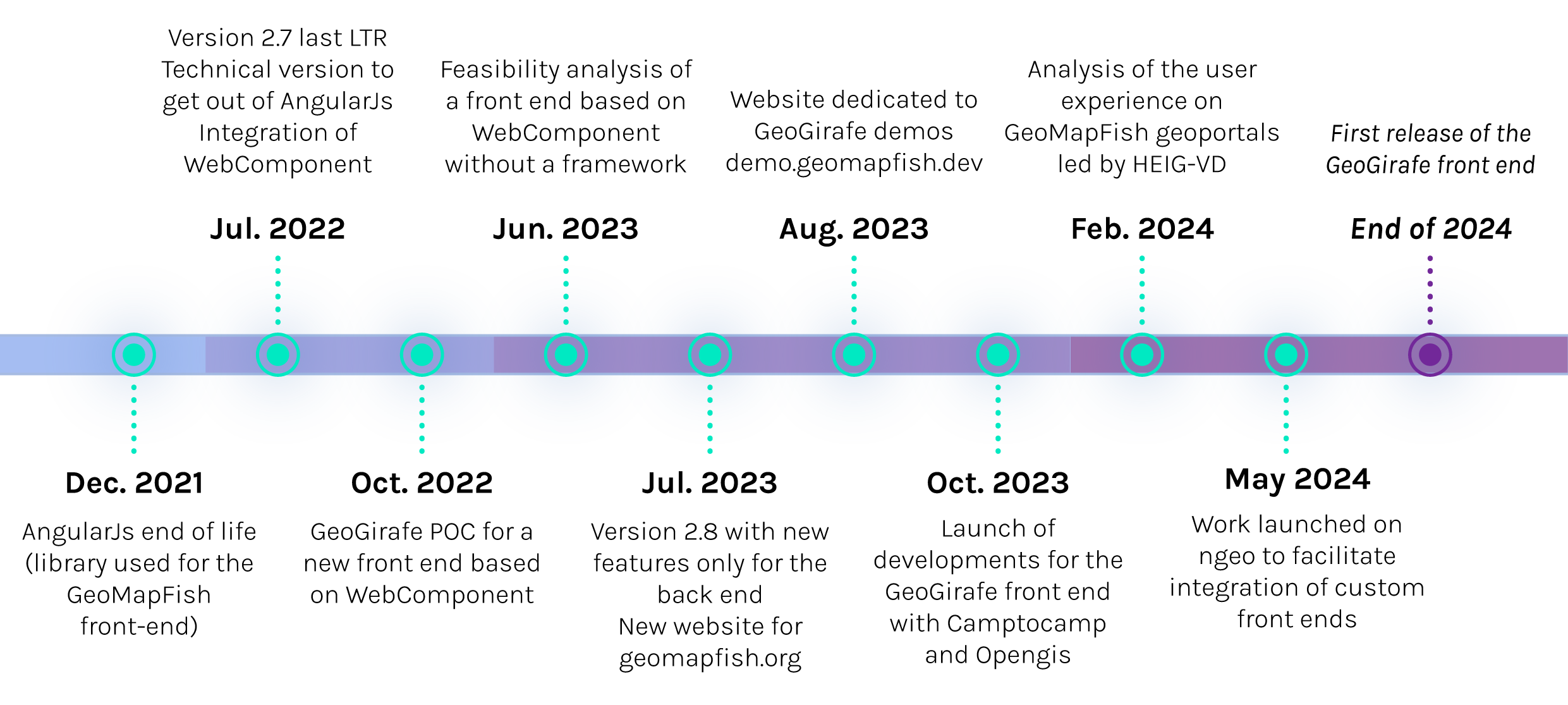
GeoGirafe roadmap
GeoGirafe is the next version of the GeoMapFish viewer, currently under development.


Previous versions
Release date : july 28, 2023
Documentation : camptocamp.github.io/c2cgeoportal/2.8
Amberjack 2.8 is the latest stable release of GeoMapFish, and the new features concern only the back-end.
Technical changes
- Use main_ogc_server in WMS URL
- [Mobile] Connexion panel is open when secured layers are listed in permalink
- Investigate tiles loading performance
- Possibility to add the username in the print ouput when user is connected
- Full text search improvement (when several layers have the same name, it’s possible to add the name if the group or theme to which they belong)
- Disabled user should not be able to stay connected
- Add simple history for changes made in admin tool
- PKCE Support for oAuth
Release date : july 7, 2022
Documentation : camptocamp.github.io/c2cgeoportal/2.7
Snook 2.7 is release with a purely technical migration, it doesn’t include any additional features. Its aim is to prepare GeoMapFish to stop using AngularJS, which is no longer supported since 2021.
Technical changes
- Web Component implementation
- Migration of Feedback form to Web Component
- Migration of authentication to Web Component
- Added documentation for the “Administration” section
- WFS 3 support for QGIS
- Improved theme loading speed
- Merge of ngeo/GMF code
- First implementation of vector tiles
Release date : Spring 2021
Documentation : camptocamp.github.io/c2cgeoportal/2.6
New functionalities
Interface
- [2.6.24] Push a message to user when server authentication is lost
- [2.6.32] Right panel resizable for all tools
Query
- [2.6.10] CSV export in Window
- [2.6.46] Define a per layer click tolerance
- [2.6.53] Scale limit on WMTS query
Search
- [2.6.26] Possiblitiy to add keywords to layers in order to find them easier
- [2.6.27] Full-text-search for layers
- [2.6.29] Handle case with layers with a legend too big to show on one A4 sheet
Permalink
- [2.6.25] See the configuration of the timeslider/timepicker before sharing
Measure and redlining
- [2.6.1] Draw an arrow
- [2.6.31] Snapping functionality for measuring and drawing tools
Editing
- [2.6.20] Check data type and display warning before saving
- [2.6.22] Add a column named “order”, in order to sort dropdown lists
- [2.6.51] Allow editing of overlayed geometries (editing and redlining)
External data
- [2.6.34] Display legend of imported WMS layers
- [2.6.35] Interrogation of external WMS with GetFeatureInfo
- [2.6.47] Drag & drop files to show them on map
Release date : April 23, 2020
Documentation : camptocamp.github.io/c2cgeoportal/2.5
New functionalities
- Improve WMS browser (search, server list)
- Map slider (swipe between maps)
- Improve redlining, be able to define length, size
- Close legend automatically when layer is deactivated
- Display snappable layers and enable activation/deactivation
- Intranet user panel
- Show and validate mandatory fields in editing form
- Timeslider improvements (dynamic map rendering)
- Be able to define min and max scale for WMTS
- Let filters active even if panel is closed
- Query using a polygon
- Global loading & counter message
- Long name cut off in display window
- Story maps
- KML styling (import & export)
- Be able to use desktop on a tablet
- Geolocation on desktop interface
- WMS GetFeatureInfo on non WFS servers
- Security – No cached credentials
- Security – Configurable account lockout
- Security – Secure password storage
- Security – Session timeouts
- Architecture – Docker only
Release date : July 7, 2019
Documentation : camptocamp.github.io/c2cgeoportal/2.4
New functionalities
- IFRAME integration
- Editing – Column order
- Editing – Read only attributes
- Editing – Link to external form
- Drawing – Delete vertex menu
- Drawing – Zoom on recenter
- Read only drawing on mobile
- Layer tree – Resize panel
- Layer tree – Radio buttons
- Query – Auto-link in results
- Interface – App loading widget
- Interface – mobile first level panel title
- A0 printing
Release date : May 23, 2018
Documentation : camptocamp.github.io/c2cgeoportal/2.3
New functionalities
- WMS / KML browser integration + permalink
- Map rotation
- Moving Window & query result / resizing
- Administration interface
- Result window optimization
- Layertree flush / no flush in mobile version
- Opacity for layers in mobile version
Release date : January 22, 2018
Documentation : camptocamp.github.io/c2cgeoportal/2.2
New functionalities
- Query builder and filters
- WFS query: take time into account
- Not found text in fulltextsearch
- Street View integration
- Clear all button in layertree
- User defined scales for printing
- Android web browser compatibility
- Predefined transparency for WMS / WMTS